


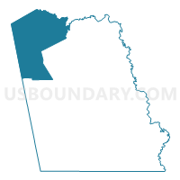
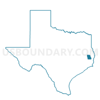
Voting District 0007, Tyler County, Texas
About
Outline

Summary
| Unique Area Identifier | 677871 |
| Name | Voting District 0007 |
| County | Tyler County |
| State | Texas |
| Area (square miles) | 126.56 |
| Land Area (square miles) | 126.47 |
| Water Area (square miles) | 0.09 |
| % of Land Area | 99.93 |
| % of Water Area | 0.07 |
| Latitude of the Internal Point | 30.95337510 |
| Longtitude of the Internal Point | -94.55969810 |
Maps

Graphs
Select a template below for downloading or customizing gragh for Voting District 0007, Tyler County, Texas


Neighbors
Neighoring Voting District (by Name) Neighboring Voting District on the Map
- Voting District 0001, Jasper County, TX
- Voting District 0008, Tyler County, TX
- Voting District 0010, Polk County, TX
- Voting District 0010, Tyler County, TX
- Voting District 0011, Polk County, TX
- Voting District 0011, Tyler County, TX
- Voting District 0017, Angelina County, TX
- Voting District 0018, Tyler County, TX
- Voting District 0032, Angelina County, TX
Top 10 Neighboring County Subdivision (by Population) Neighboring County Subdivision on the Map
- Livingston-Onalaska CCD, Polk County, TX (40,554)
- Jasper CCD, Jasper County, TX (17,991)
- Huntington CCD, Angelina County, TX (11,260)
- Woodville CCD, Tyler County, TX (10,417)
- Corrigan CCD, Polk County, TX (4,859)
- Colmesneil-Chester CCD, Tyler County, TX (2,985)
Top 10 Neighboring Place (by Population) Neighboring Place on the Map
Top 10 Neighboring Unified School District (by Population) Neighboring Unified School District on the Map
- Woodville Independent School District, TX (11,154)
- Zavalla Independent School District, TX (2,975)
- Colmesneil Independent School District, TX (2,461)
- Chester Independent School District, TX (1,274)
Top 10 Neighboring State Legislative District Lower Chamber (by Population) Neighboring State Legislative District Lower Chamber on the Map
- State House District 18, TX (150,998)
- State House District 12, TX (149,506)
- State House District 9, TX (145,381)
Top 10 Neighboring State Legislative District Upper Chamber (by Population) Neighboring State Legislative District Upper Chamber on the Map
Top 10 Neighboring 111th Congressional District (by Population) Neighboring 111th Congressional District on the Map
Top 10 Neighboring Census Tract (by Population) Neighboring Census Tract on the Map
- Census Tract 9502, Tyler County, TX (7,895)
- Census Tract 9501, Jasper County, TX (6,030)
- Census Tract 13, Angelina County, TX (5,181)
- Census Tract 2104, Polk County, TX (4,859)
- Census Tract 2105, Polk County, TX (4,692)
- Census Tract 9501, Tyler County, TX (2,985)
Top 10 Neighboring 5-Digit ZIP Code Tabulation Area (by Population) Neighboring 5-Digit ZIP Code Tabulation Area on the Map
- 75979, TX (11,423)
- 75949, TX (7,976)
- 75939, TX (3,992)
- 75980, TX (2,836)
- 75938, TX (2,608)
- 75936, TX (889)